Hereford Mappa Mundi
Mappa mundi is the general term for a medieval European map of the world. The word ‘mappa mundi’ is latin, and its plural name is mappae mundi. The term derives from the medieval latin words mappa (cloth, towel or chart) and mundus (world). These maps vastly range in size and complexity; from simple tiny maps less than 1 inch in diameter, to large elaborate wall maps that can reach several feet in diameter.
Just over 1,000 mappae mundi are known to have survived worldwide from the Middle Ages. Of these, some 900 are found illustrating manuscript books and the remainder exist as stand-alone documents.
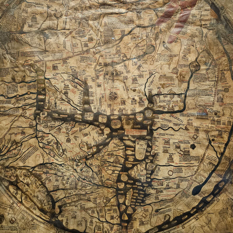
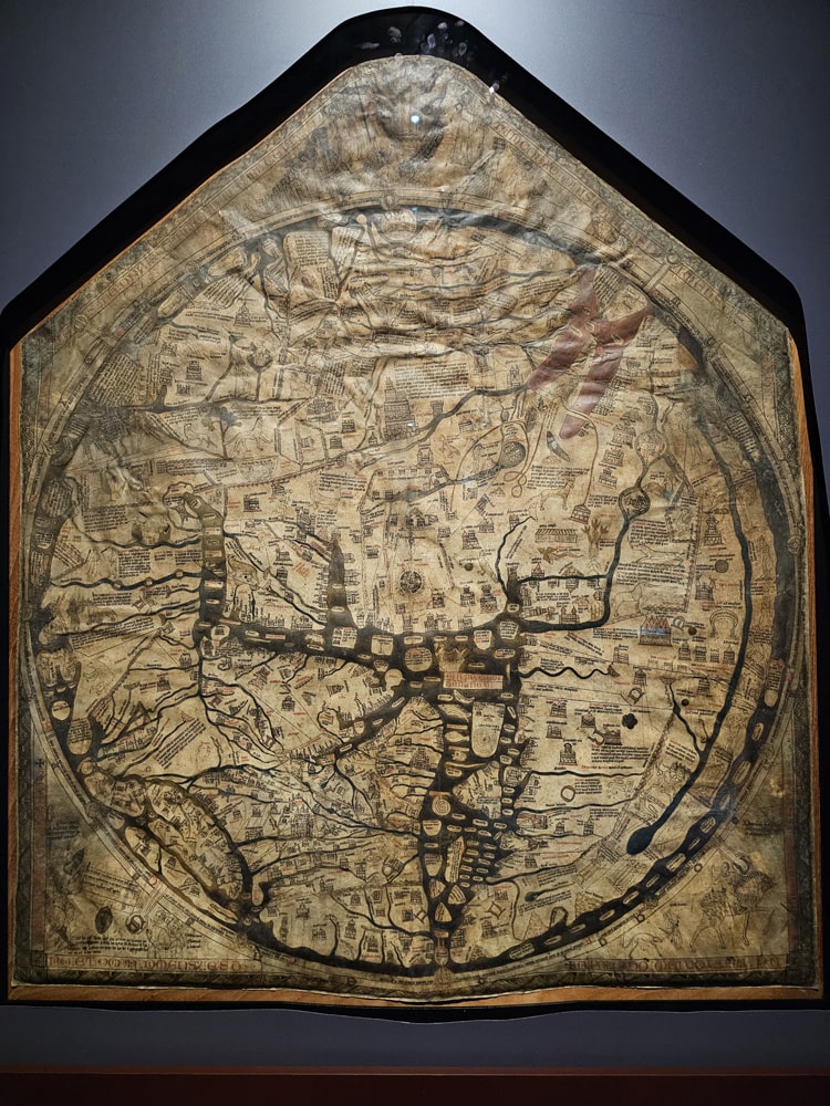
Hereford Cathedral is home to the oldest surviving mappa mundi – the Hereford Mappa Mundi. It’s called the Hereford Mappa Mundi because the medieval original is in Hereford Cathedral. The majority of the medieval maps of the world that survive today were not designed for travel. It is therefore a mystery how the Mappa Mundi actually came to be at Hereford Cathedral. Some scholars believe it may have been created in Hereford, but there are clues that actually link it to Lincoln Cathedral, where the map’s creator is believed to have worked.
The Hereford Mappa Mundi is not only the oldest map of its kind, it’s also the largest medieval map still known to exist, depicting the known world. It is generally believed that the map was created some time around the late 1290s – 1300. It was written in English Gothic script by Richard of Haldringham. The map is constructed on a single sheet of vellum (flayed calf’s skin) and measures 5’2″ by 4’4″.
The map is a religious depiction rather than a literal depiction; featuring heaven, hell and the path to salvation. It shows the history, geography and destiny of humanity as it was understood in Christian Europe in the late 13th and early 14th centuries. The map is covered in well-known biblical narratives and contains over a thousand pictures and captions, revealing how medieval Christians understood the world.
The inhabited parts of the world as it was known then was Europe, Asia and North Africa. The map is about spiritually travelling towards god rather than getting from one place to another. Jerusalem is in the centre of the map, with Christ at the very top overseeing the Day of Judgement. East is at the top, showing Adam and Eve in the Garden of Eden, and to the west is Spain and modern-day Gibraltar. North is to the left and ends in Russia, while south is to the right, which depicts Africa. And finally, the British Isles is at the bottom on the left of the map.
The Hereford Mappa Mundi truly is one of the world’s most important and unique medieval treasures. I saw it for myself on my trip to Hereford Cathedral along with the chained library and it was incredible. There was a fee of £7.50 to enter that part of the cathedral to view both the Mappa Mundi and the chained library, but it was well worth it.
Did you enjoy this post?
I hope you found this post useful. I put a great deal of time and effort in to building, maintaining and populating the website. If you like, you could say a small thank you by buying me a coffee. You don't have to, but it would be nice :)
Buy me a coffee
Stay up to Date
Follow me on my journey and get notified whenever a new post is published by following Kings & Castles on Facebook.
Follow MeExplore The Map
Discover the hundreds of castles, churches, monasteries, cathedrals and other historic locations that I've personally visited across England and Wales. Search by location, explore nearby sites and plan your next historical adventure.
Share: