Domesday Book
Domesday Book is a comprehensive record of the extent, value, ownership, and liabilities of land in England, completed in 1086 on the orders of King William I of England, more commonly known as William the Conqueror. It demonstrated the power of William’s government and was unique across Europe at the time. The next survey with the same level of information wouldn’t be created for another eight centuries.
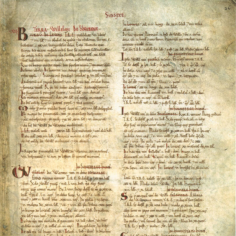
What is the Domesday Book?
William the Conqueror was King of England from Christmas Day 1066, and almost 20 years into his reign he ordered a survey to be made of all land holdings in England, and commissioned the Domesday survey in 1085, which was completed the following year. After the Norman conquest of England in 1066, huge amounts of land in England changed hands, and the Domesday survey was designed to record and keep track of these changes, such as:
- Land ownership: Who owned the land, how much they owned, and the value of the land
- Land use: How the land was used, including the number of peasants and plough teams working the land
- Resources: The value of livestock, churches, mills, and other economic resources
- Taxation: The value of each estate and the new system of taxation on each estate
- Rights and dues: What rights and dues were owed to the King
- Military resources: The liability of barons to provide military resources to the King
The scope, speed and efficiency of the survey was remarkable for its time and resulted in the two-volume Domesday Book of 1086: Great Domesday and Little Domesday. It was one of the greatest administrative accomplishments of the Middle Ages, which still exists today. It was the first census or survey of its kind, and along with the Magna Carta, it is one of England’s most iconic documents. The original book is kept at the National Archives in Kew, London, and is the oldest government record in the archives.
Why Was it Called ‘Domesday Book’?
It gets its name from the Old English words ‘dom’ meaning ‘judgment’ and ‘dæg’ meaning ‘day’. The name refers to the book’s definitive nature and its similarity to the Last Judgment, or Doomsday, in Christianity. This name was given to the book by the Anglo-Saxon citizens, who felt like they were being assessed like they would be on the Christian Judgement Day by God.
Why Was the Domesday Book Created?
King William wanted to know how much money and resources he had, and the Domesday Book helped him maintain control throughout his kingdom. He was able to see which of his barons owned land throughout England, enabling him to raise taxes easily because he knew how much each village could afford to give. It was also very effective in giving William knowledge of how much of an army he could raise if nearby kingdoms were to attempt to invade England. Additionally, the survey exerted power over the people of England; they knew that their barons and king had detailed information about what they owned and how much money they made.
The decision to create a survey of all the resources in the country was taken at William’s Christmas court in Gloucester in 1085. He and his closest advisors decided to send out ‘commissioners’ to every part of the kingdom. Their task was:
“To go all over England, into every shire and find out who many hides there are, what lands and cattle the king had himself in that shire and what dues (taxes) he ought to have in twelve months.
It must be investigated that no single hide nor yard of land, nor indeed one ox or cow or pig is left out and not put down in his record.”
How Was the Domesday Book Compiled?
The Domesday survey was only possible because England already had a very sophisticated administrative system and an efficient tax system in place. The Anglo-Saxons had already established a kingdom with separate shires (whose boundaries survived with little change until 1974), which were further divided into hundreds, and each shire had an ealdorman and shire-reeve to look after the king’s interests such as collecting taxes and administering justice.
The commissioners travelled throughout the country to write down the information they needed, visiting each shire (county) and would move from town to town for several months. A commissioner would arrive in a town or village and set up an assembly, which would then gather lists of all the resources of that town or village. In addition to the efficient administrative and tax systems already established by the Anglo-Saxons, the feudal system was also a large part of the reason that William was able to conduct his survey.
What Questions Were Asked?
The commissioners were given specific questions to ask and resources to find, these included:
- What the manor was called
- Who held it before King William’s rule
- Who holds it now
- How many hides there are (measurement of land)
- How many ploughs the lord and peasants had
- How many freemen
- How many slaves
- How much woodland
- How much meadow
- How much pasture
- How many mills
- How many fisheries
- What is the entire estate worth
Each of these questions had to be answered three times, the first answer was as it was when King Edward the Confessor ruled (before 1066), the second answer as it was during the Norman conquest (1066), and the third answer as it was at the time of the survey.
The Results of the Domesday Survey
Domesday Book provided definitive proof of rights to land and obligations to tax and military service, and was used for many centuries for administrative and legal purposes. It is almost 1000 pages in length, written in Medieval Latin with around two million words, and describes the inhabitants and resources of more than 13,000 places in England and certain border areas of Wales, most of which still survive today. Strangely, the survey didn’t cover certain important cities such as London, Winchester or Bristol. Nor did it include much of north-west of England such as Northumberland and Durham. The reasons for this are unknown, but it could have been due to William’s ‘Harrying of the North‘ where the land was reduced to a ‘wasteland’ after he a crushed a major rebellion in the north of England, burning the villages and starving its people.
The survey may not have been a full population census, and the names that appear in it are mainly those of people who owned land, but nevertheless, it was an exercise unparalleled in contemporary Europe, and wasn’t matched in its comprehensive coverage of the country until the population censuses of the 19th century.
The creation of the Domesday Book allowed William to decide who to lease the land to. He rewarded his closest supporters with large areas of land to manage on his behalf, and his new system of taxation allowed him to raise more money from all landholders quickly. The king and his family held about 17 per cent of the land, bishops and abbots of the church owned 26 per cent of the land, and around 190 tenants-in-chief (barons) held about 54 per cent. Some of the holdings by these barons were huge, twelve of the barons controlled nearly a quarter of the country. Anglo-Saxon names appear mainly as ‘under-tenants’ of Norman lords. Some 4000 to 5000 entries relate to Anglo-Saxon lords. Most of the land originally owned by 2000 Anglo-Saxons belonged to 200 Norman barons in 1086, showing just how powerful the Norman lords had become.
Of the almost 300,000 individuals described in the Domesday Book, almost 40 per cent were listed as Villani. These people may have been the tenants or peasants of the barons, but they were the aristocracy of the peasant class, such as villagers and freemen. They worked the land and paid taxes to their baron. Some of the wealthier Villani recorded in the Domesday Book owned farms as large as 30 acres, but still had to work for their baron. The Domesday Book also revealed that bout 10 per cent of the population were enslaved, who had no property rights and could be bought and sold to work the land. However, by the middle of the 12th century, the institution of slavery as it had existed prior to the Norman conquest had fully disappeared.
Did you enjoy this post?
I hope you found this post useful. I put a great deal of time and effort in to building, maintaining and populating the website. If you like, you could say a small thank you by buying me a coffee. You don't have to, but it would be nice :)
Buy me a coffee
Stay up to Date
Follow me on my journey and get notified whenever a new post is published by following Kings & Castles on Facebook.
Follow MeExplore The Map
Discover the hundreds of castles, churches, monasteries, cathedrals and other historic locations that I've personally visited across England and Wales. Search by location, explore nearby sites and plan your next historical adventure.
Share: